Determination of runoff generation
and its spatial distribution using DOC and d18O
as tracers
by
Markus C. Casper,
Holger N. Volkmann
Institut für Wasserwirtschaft und Kulturtechnik, Universität
Karlsruhe (TH), Kaiserstr. 12, D-76128 Karlsruhe, Germany
http://duerreych.bau-verm.uni-karlsruhe.de
e-mail: markus.casper@bau-verm.uni-karlsruhe.de
Fax: 0049 721 661329
Tel.: 0049 721 608-4222
Download
as WinWord97-File
(This paper is not elsewhere published)
Table of Contents
Abstract
Introduction
Organic Substances in Surface
Waters
Site description
Methods
Results and Discussion
Conclusions and Outlook
References
Abstract:
In order to distinguish runoff generation processes, investigations
of the spatial and temporal dynamics of dissolved organic carbon (DOC)
export and d 18O (VSMOW) in precipitation,
soil water and runoff were carried out in the catchment Duerreychbach (northern
Black Forest, Germany). For a headwater DOC measurements during selected
precipitation-runoff events were used to distinguish the dominating runoff
processes and their chronology. The DOC-rich water originated from the
upper soil horizons and acted as a rapid runoff component. Runoff was found
to be dominated by lateral percolation through the upper soil horizons
The combination of DOC and d 18O
data in a mixing diagram allowed to quantify the fraction of event water.
In opposition to d 18O, DOC concentrations
always showed a distinct contrast between soil water and precipitation
water. Determination of a representative mean pre-event value for both
DOC and d 18O was difficult, but
the possible range of soil DOC concentrations was rather limited and fell
between 68 to 80 mg 1-1 in our study. Using a DOC mass balance
approach, a hydrograph separation for the Duerreychbach catchment succeeded
for low antecedent soil moisture or low precipitation sums: The headwater
covering only 22% of the catchment delivered approx. 98% of the total DOC
load and more than 50% of the water. Increasing precipitation sums or wetter
antecedent soil moisture increased the connectivity of other areas to the
main channel, which then contributed about 52% of the exported DOC.
INTRODUCTION
Knowledge of runoff generating processes is fundamental for testing
and improving predictive rainfall-runoff models. Moreover, expected changes
in climate or land use require models, which are capable of predicting
the resulting changes in runoff dynamics and water quality. Therefore,
the knowledge of the dominating runoff generation processes and their interactions
is important in order to prove a model's applicability for these purposes
(Bonell, 1998; Buttle, 1994; Mehlhorn et al.,1999).
To identify the dominating runoff processes, flow paths need to be tracked.
Here the chemistry of water solutes can provide valuable information (Bishop
1991; McDowell & Likens, 1988; Easthouse et al., 1992). In addition,
the analysis of stable isotopes is a common method to provide data on sources
of runoff (Bishop, 1991; Buttle, 1994; Ambroise et al., 1995; Brown
et
al., 1999). It allows to separate event water (rain or throughfall)
and pre-event water which was stored as soil or ground water prior to the
event. However, a significant contrast in isotopic composition of event-water
and pre-event water is essential.
Hydrometric, isotopic and hydrochemical data complement to each other.
Hence, a data set covering a wide range of event characteristics and antecedent
soil moisture conditions of the catchment helps to elucidate the sources
and flow paths of water and allows to understand the relative contributions
and the dynamics of the different runoff generation processes (Bonell,
1998).
In this study selected rainfall-runoff events were analysed to describe
the sequence of dominating hydrological processes, to quantify surface
runoff, and to estimate the contribution of three nested subcatchments
to runoff. Investigations with the natural tracers d18O
(VSMOW) and dissolved organic carbon (DOC) were performed to estimate proportions
of event and pre-event water during runoff events. The analysis of DOC
dynamics was used to describe the sequence of dominating hydrological processes
and to quantify surface runoff.
ORGANIC
CARBON IN SURFACE WATERS
Natural organic substances play a major role in the description of ecosystems,
since they characterise the linkage of organisms with their environment.
Soil processes such as accumulation, turnover and export of organic carbon
play an important role in the ecosystem, driven by water as the transport
medium (McDowell and Wood, 1984). Thus knowledge of the fluxes of DOC can
contribute significantly to the understanding of runoff generation (Hooper
et
al., 1990). For dissolved organic matter there exist various
terms with overlapping or partially matching definitions. Perdue &
Gjessing (1989) described DOC as complex mixture of natural dissolved organic
acids. In this study DOC refers to the fraction of total organic carbon
(TOC), that passes a 0.45 µm pore-diam-filter (EN 1484 ,1997; Eaton
et
al., 1995). This definition also comprises the fraction of humic substances,
which are refered to as coloured organic substances of natural origin,
derived from biogenetic transformation (Allard et al., 1991), or sum of
the fractions humic and fulvic acids, obtained by a fractionation procedure
of organic substances with XAD-8 resin (Thurmann, 1981; Malcom, 1989).
DOC occurs in soil water, natural aquifers and drinking water in concentrations
between 0.1 to 80 mg l-1 (Wetzel and Corners, 1977; McDowell and Likens,
1988; Scott et al., 1998). In temporate regions the portion of DOC in streams
usually exceeds the particulate organic matter by one order of magnitude.
In aquatic systems the significance of DOC is abundant. In the food chain
for example it plays a central role. Low order streams like the Duerreychbach
are basically heterotrophic ecosystems that obtain almost all of their
DOC from terrestrial primary production (Hynes, 1963), which continuously
delivers organic matter. Partly transformed by biological degradation soluble
fractions reach the stream, carried by precipitation water through the
soil (Mulholland et al., 1990). In their study Fiebig and Lock (1991)
described immobilisation dynamics of DOC in the stream bed. They observed
in laboratory experiments, that substantial amounts of DOC in groundwater
can be adsorbed to the stream sediment and consumed by microorganisms.
Nevertheless due to rapid degradation in the soil the fraction of bioavailable
organic carbon in the stream water is usually below 10% of the total organic
carbon, based on steady state concentrations (Frimmel, 1990). Especially
in waters with a high load of humic substances the recalcitrant components
dominate. In particular during stormflow the Duerreychbach carries water
with a dark brown colour caused by the high concentration of humic substances.
On the other hand adsorption and desorption dynamics of organic solutes
at sediment surfaces have to be considered. Own extractions of DOC with
NaOH have shown, that sediment surfaces of both, streambed and spring sediments
of the Duerreychbach were highly loaded with humic substances, revealing
rather slow desorption processes. The amount of humic substances indicated,
that the sediment surfaces were almost saturated. Since travel time of
water from the headwaters to the main gauge seldom exceeded a few hours,
we considered DOC to be a conservative water solute. The biological stability
and the variability of mobilisation processes depending on soil characteristics
are preconditions for the use of DOC as a tracer of water from different
source areas and different flow paths through the soil into the stream.
SITE DESCRIPTION

Figure 1: Site map of the hydrological
test site Duerreychbachtal: subcatchment delineation and instrumentation
The Duerreychbach catchment is a 700 ha V-shaped valley covered with
coniferous forest in the northern Black Forest, SW-Germany, with elevations
between 600 and 950 m a.m.s.l.
Mean precipitation is 1530 mm a-1 with a mean temperature
of 6-7°C. The bedrock is Triassic sandstone covered by deep blocky
periglacial regolith. The very steep slopes are carved by corries and topped
with humid plateaux. Typical soils are podzols, stagnic gleysols or degraded
peats. For this study the catchment was subdivided into two nested headwater
catchments LE (27 ha) and SH (156 ha) and the subcatchment DUE (544 ha)
(Figure 1).
The headwater LE is characterised by a flat humid plateau and relatively
flat hillslopes. It is closely linked to the stream by a dense artificial
drainage system. Soils with stagnic or peaty properties cover 50% of the
area (Figure 2). Discharge was only activated during periods of high soil
moisture content or after a heavy rainfall. The catchment SH includes LE
and shows similar characteristics. 32% of the soils have peaty and stagnic
properties. In addition, it comprises a plain which was deforested by a
wind break in 1991. Though, during wet periods a small periodic spring
contributes to the catchment discharge, the stream channel falls dry periodically.
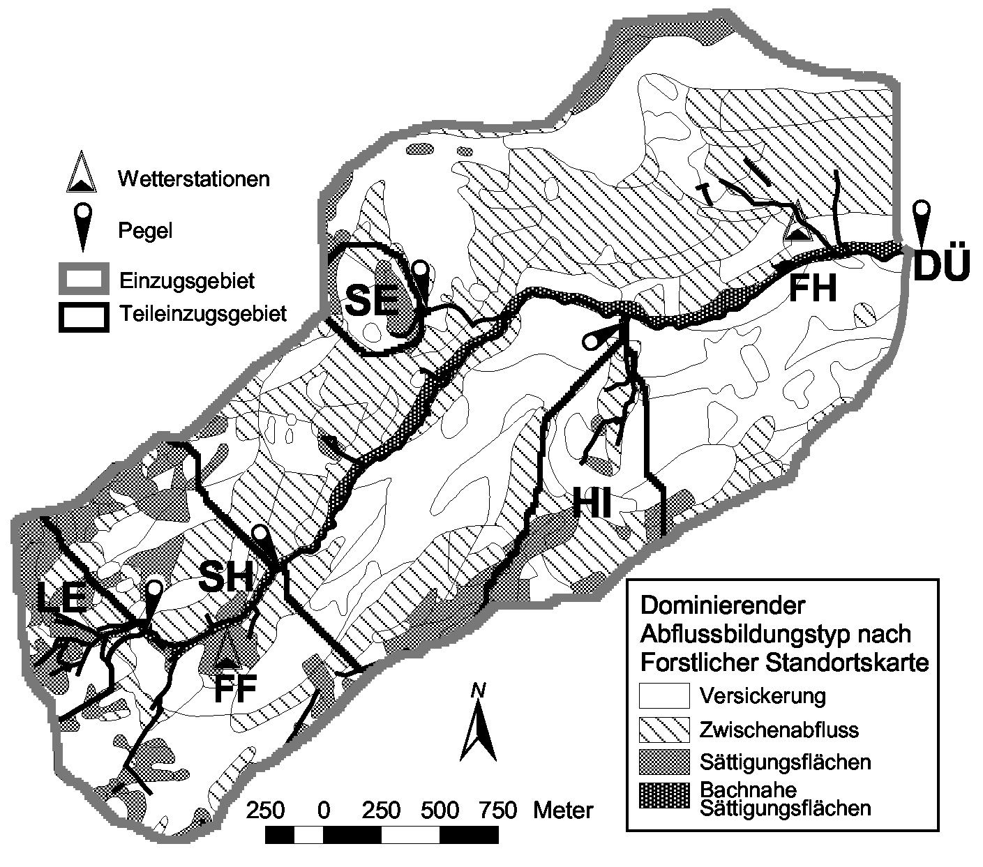
Figure 2: Distribution of peaty or
stagnic soils in the Duerreychbach catchment
The subcatchment DUE has steep slopes. Except for the alluvial plain
of the narrow valley floor, soils with stagnic or peaty properties are
only found in corries and on the mountain tops and cover only 10% of the
area. They have a low connectivity to the main stream due to a sparse drainage
system and great distances. Podzols are dominant on the forested slopes.
Discharge is observed at the catchment outlet all year round. In dry periods
only three perennial springs are contributing to runoff (Figure 2).
METHODS
Field measurements
As shown in Figure 1, the study area was equipped with several gauging
sites. Two weather stations provided data of precipitation, air temperature,
soil temperature and soil moisture content. Soil moisture content was measured
by TDR probes at 20 and 35 cm below the surface. V-notch weirs with a pressure
gauge connected to ISCO autosamplers were used for measurements of water
levels at LE and SH. A rectangular weir was installed at DUE. Runoff was
calculated with a stage-discharge curve deduced from the weir geometry
and calibrated with bucket measurements and the salt dilution method according
to Rodel (1993). Using the salt dilution method flow velocity and discharge
were measured temporary for a number of points along the main channel.
Water samples were taken at intervals of 48 hours, and during runoff events
at intervals of 3 hours. Soil water was collected weekly with PE/Nylon
suction cups at depths between 5 and 70 cm of a podzol soil which is the
dominant soil type of the study area.
Laboratory methods
Determination of DOC concentrations in runoff and soil water was carried
out by IR detection of CO2 after combustion at 950°C with
synthetic air with a HighTOC analyser (Elementar, Hanau/Germany) with an
accuracy of ± 2%. Atomic mass spectrometry
was used to determine d 18O (VSMOW)
with a gas ion mass spectrometer and Aquaprep (Micromass Optima). The sample
were prepared with the "glove bag technique". The accuracy is ±
0.15.
Delineation of subcatchments
Using a GIS (Arc/Info 7.2) and a hydrologically corrected, high resolution
DEM (10 meters grid size) subwatersheds were delineated by defining the
corresponding source points. The results were confirmed by field survey.
Hydrograph separation techniques
Different hydrograph separation techniques were applied: (1) two-component
isotopic separation (Bishop, 1991; Brown et al., 1999), (2) two-component
separation using DOC as a tracer, (3) two-tracer, two-component end-member
mixing analysis (Christophersen and Hooper, 1992)
1. Two-component isotopic separation for the headwater LE.The
technique (Bishop, 1991; Brown et al., 1999) is a mass-balance approach
that separates stormflow into pre-event water (in our case: water stored
in the soil prior to the event) and event water on the basis of the stable
isotope ratio of each component:
 (1) (1)
where Q is discharge, C is the d 18O
composition. The subscripts s, p, e represent the streamflow, pre-event
and event components, respectively. The relative contributions of pre-event
and event water were calculated for each sample. Since the isotopic composition
of the pre-event (soil water) component was unknown (no discharge during
dry periods) it was determined using a DOC-d18O
mixing diagram. The isotopic composition of event water was calculated
as the weighted mean of the precipitation samples
2. Two-component separation using DOC as tracer. Since runoff
from the plateau area (headwaters LE + SH) showed a stable (only +/-10%
variation during event) and very high concentrations of DOC, we used DOC
similarly to d 18O: for the catchment
outlet we calculated the instantaneous fraction X(t) of runoff which originates
from those areas:
 (2) (2)
where:
CDOC(t): DOC concentration at catchment outlet, CDOC(t
= 0): DOC background concentration at catchment outlet and CDOC(Plateau):
constant DOC concentration from export area.
3. Two-tracer, two-component end-member mixing analysis (Christophersen
and Hooper, 1992). To estimate the isotopic composition of pre-event water,
both isotope and DOC data were analysed. Since DOC and d18O
show a strong correlation we determined the mixing line for pre-event and
event water by plotting all measurements in a bivariate DOC/d18O
diagram (Figures 6b and 7b). Since the exact position of the end member
"soil water" was unknown, we incorporated additional information. First
we used d18O data from a soil profile
nearby. Second we made the assumption that the last pre-event measurement
of low flow DOC concentration is the lower limit for the actual DOC concentration
of the soil water. This allowed us to find a better estimation for the
actual d18O content of soil water
by plotting the DOC value on the mixing line and reading the corresponding
d18O
value (detailed example in Figure 6b).
RESULTS AND DISCUSSION
Spatial and temporal distribution of DOC concentrations
DOC concentrations measured in the stream varied between 0.5 and 81
mg l-1. The highest concentrations were observed during stormflow
in the headwater catchments. The DOC concentrations of soil water decreased
with increasing soil depth. In the soil water of a podzolic soil profile
highest concentrations and dynamics of DOC were obtained
in the upper soil horizons. DOC concentrations of a perennial spring in
the Duerreych valley never exceeded 1 mg C l-1. This is coherent
with earlier studies about the adsorption kinetics and sources of DOC in
soils (McDowell and Wood, 1984; McDowell and Likens, 1988; Kaplan et
al., 1980; Dalva and Moore, 1991): The deeper the water percolates
through the mineral soil, the more DOC is adsorbed to the soil body and
degraded Thus in the Duerreychbach stream water with a high DOC concentration
must originat from the upper soil horizons and traced rapid runoff components
(Brown et al., 1999).
Headwater LE

Figure 3: Soil moisture response on
a precipitation input
The two nested headwaters LE and SH showed a very similar hydrological
and hydrochemical behaviour. For the following description of runoff processes,
we focus on the headwater LE.
Soil moisture reaction to precipitation input is shown in Figure 3.
Initially, percolating rain caused only a slight increase in water content.
Soil moisture rose quickly to total saturation, starting in greater soil
depths, gradually saturating the soil body completely. The time lag between
main precipitation input and total saturation indicated strong lateral
flow components. Due to low slope and the high infiltration capacity, the
headwater represents a potential area of saturation excess flow (Peschke,
1999). Hortonian overland flow was excluded.
Three typical rainfall-runoff events (events A,C and K in Table I) and
the corresponding soil moisture, discharge and DOC concentration of the
LE catchment are shown in Figure 4.
| Table I. Event characteristics. |
|
Event number
|
Date
|
Precip. sum [mm]
|
Max. intensity [mm h-1]
|
Pre-event condition *
|
|
A
|
5.9.1998
|
20
|
7
|
Dry
|
|
B
|
5.10.1998
|
28
|
5
|
(very) Wet
|
|
C
|
24.10.1998
|
43
|
4
|
Intermediate
|
|
D
|
11.5.1999
|
60
|
6
|
Wet
|
|
E
|
7.7.1999
|
27
|
13
|
Intermediate
|
|
F
|
14.7.1999
|
39
|
21
|
Intermediate
|
|
G
|
4.8.1999
|
42
|
30
|
Dry
|
|
H
|
22.9.1999
|
8
|
2
|
Dry
|
|
J
|
3.10.1999
|
17
|
4
|
Intermediate
|
|
K
|
16.9.2000
|
100
|
12
|
Dry
|
| * Wet: wetness front above 20cm
depth; Intermediate: wetness front between 20 and 35 cm depth; Dry: wetness
front below 35cm depth (TDR probes at weather station in headwater SH) |
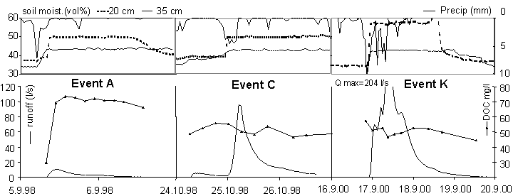
Figure 4: Three precipitation-runoff
events as examples for the reaction of the catchment on precipitation (events
A,C and K, Table I)
The precipitation input was 20 mm, 43 mm and 100 mm respectively, causing
rapid runoff reactions. Despite of the different precipitation intensities
all three events showed the same decrease of DOC concentration during precipitation
on water saturated soil. Using event C from Figure 4, the sequence of the
runoff processes are described in Figure 5.
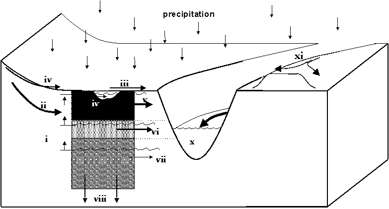 Figure 5: Model of dominating runoff processes
in the sub-catchment: (i) saturation of the soil body. (ii) lateral inflow.
(iii) saturation excess flow. (iv) return-flow. (v) lateral drainage from
the O-horizon. (vi) lateral drainage from the Ah-horizon. (vii) lateral
drainage from the B-horizon. (viii) groundwater recharge. (ix) runoff on
tracks. (x) stream discharge
Figure 5: Model of dominating runoff processes
in the sub-catchment: (i) saturation of the soil body. (ii) lateral inflow.
(iii) saturation excess flow. (iv) return-flow. (v) lateral drainage from
the O-horizon. (vi) lateral drainage from the Ah-horizon. (vii) lateral
drainage from the B-horizon. (viii) groundwater recharge. (ix) runoff on
tracks. (x) stream discharge
At the beginning of runoff the DOC concentration was low. Runoff consisted
mostly of surface runoff on forest tracks (Figure 5 (ix)), channel precipitation,
drainage of deeper horizons and a few small saturated areas near the stream
(vi, vii). The second rainfall peak caused complete saturation of the soil.
A maximum concentration of DOC in the stream was reached because lateral
runoff components through the organic layer (v) became dominant, discharging
old soil water and slowly replacing it. Further infiltration was inhibited
by water saturation, causing surface runoff in the form of saturation excess
flow (iii) , which diluted the DOC-rich soil water with precipitation water.
A new maximum of the DOC concentration was reached when surface runoff
ceased. Decreasing levels of saturation due to lateral drainage (v, vi,
vii) and groundwater recharge (viii) lowered the level of saturation and
caused a decrease of DOC concentrations because of an increasing dominance
of deeper runoff components. This is different to the study of Peters et
al. (1995), where dilution effects of laterally drained soil water
due to flushing was reported. In the headwater LE this process was considered
to be of minor importance. In other catchments the riparian zone in proximity
of the stream is regarded to be the major source of DOC (Bishop et al.,
1994; Fiebig et al., 1990). However, in the headwater LE the DOC
contributing area is too large to be exploited only by lateral flow. Nevertheless,
in addition to a vertical pattern of runoff contributors, also a spatial
pattern must be expected. The principal processes of runoff generation
can be detected on a plot scale. But the heterogeneity of the headwater
LE and the increasing responding time with increasing distance from the
stream and the gauging point might also contribute to the observed increase
in DOC in the first part of the chemograph and the decreasing DOC concentration
at the end. However, the data of DOC concentrations in soil and stream
water are not sufficient to quantify different lateral subsurface runoff
components. Here it would be necessary to find appropriate methods to characterise
DOC from different origin of mobilisation that can be found in both, soil
and stream water (Gron et al., 1996; Bishop et al., 1994).
| Table II. Portion of event water calculated
from d 18O and DOC data (headwater
LE). |
|
Event number
|
Date
|
Pre-event condition
|
Percentage runoff (27 ha)
|
Percentage event water
|
Max. DOC conc.
|
|
H
|
22.9.1999
|
Dry
|
0
|
0
|
0
|
|
J
|
3.10.1999
|
Intermediate
|
8
|
15-20
|
76.2
|
|
E
|
7.7.1999
|
Intermediate
|
10
|
22-30
|
58.7
|
|
B
|
5.10.1998
|
Very wet
|
33
|
25-32
|
60.5
|
|
D
|
11.5.1999
|
Wet
|
26
|
25-35
|
51.7
|
|
K
|
16.9.2000
|
Dry
|
34
|
30 (DOC only)
|
52.5
|
|
G
|
4.8.1999
|
Dry
|
6
|
50-60
|
42.7
|
For a number of 6 events we measured both, DOC and d18O
concentration in order to combine the potential of both tracers (Table
II). Two events are discussed in detail. One thunderstorm (event F, Table
I) on dry soil conditions (Figure 6a) showed an exceptionally high portion
of event water (50 to 60%) and a small percentage runoff of approx. 6%.
Most precipitation on the soil caused an increase in soil moisture without
contributing to runoff, while runoff on tracks was proportional to the
amount of rain. This means that only saturated areas close to the drainage
system contributed to runoff. Figure 6b shows the adjustment of the isotopic
composition of soil water. Since the measured d18O
concentration from a soil profile nearby didnt fit exactly on the mixing
line, we adjusted the d 18O value
using a measured pre-event streamwater DOC concentration of 75 mg l-1.
The diagram also shows that uncertainties in the determination of pre-event
DOC (70 to 80 mg l-1) resulted in an error of only ±0.1
for d 18O which in this case- is
below the analytical error of d18O.
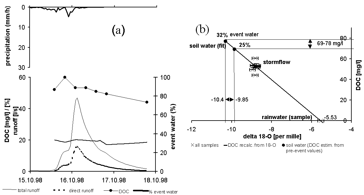
Figure 6: Hydrograph separation
at LE for wet pre event conditions (event G, Table I), (a) DOC and runoff
reaction to precipitation input, (b) adjustment of d18O
using pre-event DOC
An advective rain (event B, Table I) on wet soil (Figure 7a) produced
high discharge volumes containing a mean of 25 to 32% event water. Uncertainties
in the determination of pre-event DOC concentration (69 to 78 mg l-1)
resulted in an error of less than ±0.3 for d18O
(Figure 7b). The percentage runoff reached 33%, indicating that the area
of saturation excess flow expanded to locations not directly connected
to the main drainage system. More pre-event water ( = soil water) contributed
to stormflow in comparison to the previous event (Figure 6).
Table II shows the fractions of event water in the headwater LE for
a range of events. On dry antecedent soil moisture conditions discharge
started only after filling of the soil storage (event H with no runoff
reaction). A thunderstorm on dry soil (event F) activated only the drainage
near areas causing a high fraction of event water. Wetter pre-event conditions
resulted in higher discharge volumes but lower portions of event water,
indicating that more soil water could be exchanged during the event (events
B, D, K). Especially for smaller events on intermediate conditions, the
fraction of event water was reduced because less surface runoff was produced
(event J). In general, higher portion of pre-event water from the upper
soil layers were also verified by higher DOC concentrations (last column
in Table II).
 Figure 7: Hydrograph separation at LE
for dry pre-event conditions (event K, Table I), (a) DOC and runoff reaction
to precipitation input, (b) adjustment of d18O
using pre-event DOC
Figure 7: Hydrograph separation at LE
for dry pre-event conditions (event K, Table I), (a) DOC and runoff reaction
to precipitation input, (b) adjustment of d18O
using pre-event DOC
Hydrometric, DOC and d18O
data showed that soils with stagnic and peaty properties controlled the
runoff processes. During a rainfall event these soils
showed saturation caused by low hydraulic conductivity in deeper soil layers.
The
dominating runoff generation process is saturation excess flow (surface
and shallow subsurface runoff) with a high degree of soil water exchange
during events, indicated by the high DOC load and a low pH. The fast response
of the headwater was a result of the dense artificial
drainage system. It enhanced the runoff reaction by a better connectivity
to the main stream. Although the mixing process and mixing locations
of event water and soil water remain unclear, we suggest a mixing at the
surface-soil-interface (e.g. due to return flow), and a mixing in the stream,
where surface runoff and lateral subsoil inputs meet.
Catchment scale
On the catchment scale we used a mass balance approach of DOC for a
hydrograph separation. Figure 8 shows a hydrograph separated into 3 components
using DOC. The runoff was caused by a heavy thunderstorm (event F, Table
I) on intermediate soil moisture conditions. For this type of event, the
groundwater contribution ("baseflow") was assumed to be constant. DOC originated
exclusively from the plateau region of our catchment because all other
DOC-rich soils had no connection to the drainage system. This conclusion
was verified by the comparison of the net DOC export at the catchment outlet
(approx. 415 kg for the entire event) and at the gauge draining the headwater
SH (408 kg). An area of only 22% of the catchment (headwater SH) delivered
approx. 98% of the total DOC load and more than 50% of the water.
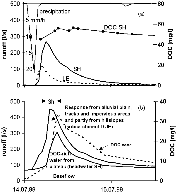 Figure 8: Event F (Table I), (a) precipitation
input and the resulting chemo- and hydrograph at SH, (b) hydrograph separation
for the main gauge using DOC
Figure 8: Event F (Table I), (a) precipitation
input and the resulting chemo- and hydrograph at SH, (b) hydrograph separation
for the main gauge using DOC
The average DOC concentration of the water from SH was 52 mg l-1.
The background concentration at the catchment outlet was 1.2 mg l-1.
Using equation (2) the instantaneous fraction of water originating from
the headwater SH was calculated for each time step of 1h at the catchment
outlet. The shape of the separated hydrograph shows both, translation and
diffusion during the flow process. The time lag between the peak discharge
at SH and the DOC peak at the main gauge was approx. 3h which fits with
flow velocity measurements in the main channel. The percentage runoff for
the headwater SH was 12%. The water added in subcatchment DUE was low in
DOC concentration. It originated mainly from tracks, impervious areas and
the alluvial plain. The percentage runoff for this subcatchment was only
3.1% and it contributed mainly to the fast runoff components. It dominated
the ascending limb of the hydrograph.
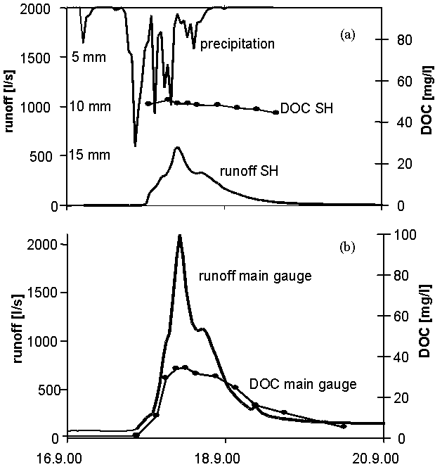 Figure 9: Event K (Table I), (a) precipitation
input and the resulting chemo- and hydrograph at SH, (b) hydrograph and
DOC concentration at the main gauge
Figure 9: Event K (Table I), (a) precipitation
input and the resulting chemo- and hydrograph at SH, (b) hydrograph and
DOC concentration at the main gauge
For events with wet antecedent soil moisture or high precipitation sums,
this simple method can not be applied. The runoff contribution from the
subcatchment DUE increased due to a better connectivity, especially of
the forest soil on the hillslopes. Figure 9 shows a sample event from September
2000 (event K, Table I). The antecedent soil moisture condition was dry.
Approx. 25 mm of rainfall was necessary to fill the soil water storage.
Then runoff started and reached its maximum after another 65 mm of rainfall
within 12 hours. The net DOC export at the catchment outlet added up to
3300 kg, whereas the headwater SH contributed only 1600 kg (48.5%). The
remaining 1700 kg (51.5%) came from the hillslope catchment DUE, where
forest soils as well as saturated areas on the mountain tops (see also
Figure 2) became connected to the drainage system. The shape of the DOC
concentration curve at the catchment outlet looked similar to the event
J (Figure 8). It also reached a similar maximum of approx. 35 mg l-1.
This may be explained by the same process delivering the DOC (saturation
excess flow with a high degree of soil water exchange causing a quite constant
DOC concentration) but now active on a larger contributing area. The average
DOC concentration of the water from SH was again 52 mg l-1.
The average DOC concentration of the water added in subcatchment DUE increased
to 25 mg l-1. In comparison to the first event, the percentage
runoff of the headwater SH increased only by a factor of 1.6 to 19%, whereas
the percentage runoff for the subcatchment DUE increased by a factor of
4 to 12.5%. The headwater SH and the subcatchment DUE became more similar
from a hydrological (percentage runoff) and hydrochemical (DOC load) point
of view.
CONCLUSIONS
AND OUTLOOK
In the observed headwaters, measurements of DOC concentrations in the
stream can be used to detect subsoil and surface runoff. DOC concentrations
and d 18O showed a strong correlation,
though they represent different processes - DOC measurements track flow
paths, d 18O detects flow sources.
Nevertheless the correlation can be explained by a broad contributing area
with a large reservoir of DOC-rich pre-event water and a good lateral mixing
of pre-event and event water during the runoff process. This is consistent
with the study of Brown et al. (1999). Hence combining the information
derived from DOC and d 18O measurements
supplemented each other and allowed a fitting of d18O
values. However, using DOC fluxes for studies of runoff processes bears
advantages besides low cost for the analysis. In opposition to d18O,
DOC concentrations always show a distinct contrast between soil water and
precipitation water. Determination of a representative mean pre-event value
for both DOC and d18O is difficult,
but the possible range of soil DOC concentrations is rather limited and
fell between 68 to 80 mg 1-1 in our study. Models for a better
determination for pre-event soil DOC are needed, since it is not completely
understood, whether soil water sampling represents the mobilisation processes
of DOC under natural conditions (Bishop et al., 1994).
For events with low precipitation sums and events with high intensities
on dry pre-conditions DOC originated mainly from the headwaters. This fact
enabled us to track this water along the main channel. In addition, the
headwaters were the areas with the highest percentage runoff. Therefore
the knowledge of the runoff generation process in headwaters is sufficient
to understand a catchment behaviour for this type of events. Increasing
precipitation sums and/or wetter antecedent soil moisture conditions result
in increasing connectivity of other contributing areas to the main channel
(Sidle et al., 2000). The hydrologic and hydrochemic similarity
of the headwaters and the subcatchment DUE increased due to a complex superposition
of runoff generation processes (Peschke, 1998). Especially knowledge of
the runoff generation on steep hillslopes (e.g. discussed in McDonnell,
1990) and the ground water reaction becomes more important to understand
the catchments response on precipitation. Only the use of additional tracers
for hydrograph separation can help to elucidate this complex interaction
of processes. In September 2000 we measured a data set which may illustrate
the direction of further investigations.
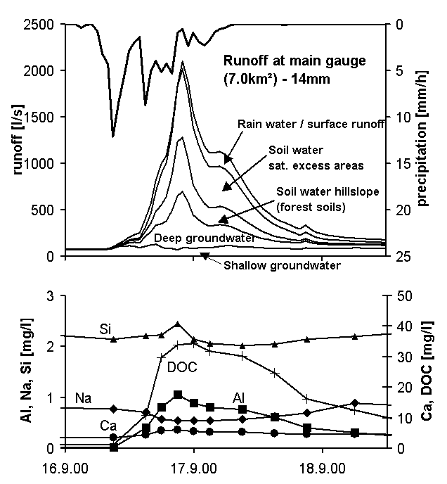 Figure 10: Event K at the main gauge (Table
I), (a) five component hydrograph separation, (b) chemographs
Figure 10: Event K at the main gauge (Table
I), (a) five component hydrograph separation, (b) chemographs
First hypothetical interpretations are given. Figure 10 shows the same
event (G in Table I) as displayed in Figure 9. Using 4 hydrochemical tracers
(calcium, aluminium, silica and DOC) we tried to separate the hydrograph
into 5 components (method according to Hoeg et al., 2000). Sodium
concentration was only used to check the results. Five reservoirs of water
were distinguished using hydrochemical data listed in Table III.
| Table III. Hydrochemical data of the
different reservoirs [mg l-1], in ( ): values used for the 5-component
separation, bold numbers indicate the main characteristics of a
reservoir. |
|
Location / reservoir (No)
|
Sodium (Na)
|
Silica (Si)
|
Calcium (Ca)
|
Aluminium (Al)
|
DOC
|
pH
|
Number of samples
|
|
Main gauge
|
0.5-1.5
|
2-2.5
|
3.0-6-0
|
0.0-1.0
|
0.5-40.0
|
5.5-6.9
|
21
|
|
Shallow groundwater (1)
|
0.75-1.4
|
2.1-2.8
(2.3)
|
1.5-4.5
(3.5)
|
0.0-0.25
(0.0)
|
0.0-1.0 (0.0)
|
4.5-5.5
|
10
|
|
Deep groundwater (2)
|
0.7-1.5
|
4.8-5.8 (5.25)
|
3-8.8
(6.0)
|
0.0
(0.0)
|
0.0 (0.0)
|
5.8-6.0
|
6
|
|
Soil water from hillslope (3)
|
0.3-1.3
|
0.1-0.6
(0.5)
|
0.5-3
(3.0)*
|
1.4-1.9
(1.9)
|
10.0-35.0
(30.0)
|
3.7-4.2
|
11
|
|
Soil water from saturation area (4)
|
0.3-0.9
|
1.3-1.9
(1.7)
|
3.0-12.0
(8.5)*
|
0.8-1.2
(1.2)
|
40.0-80.0
(70.0)
|
3.9-5.0
|
44
|
|
Rain water (5)
|
0-0.8
|
0.0 (0.0)
|
0-1.0 (1.0)
|
0.0 (0.0)
|
0.0 (0.0)
|
5-7
|
8
|
| * these high calcium concentrations
are caused by continuous liming of the forest soils and therefore trace
mainly shallow subsurface flow |
Figure 10 gives us a first guess concerning the main processes contributing
to stormflow: (1) saturation excess flow, (2) shallow subsurface runoff
and/or perched aquifers in the organic layer of the forest soils forming
the steep hillslopes, (3) direct runoff from impervious areas and direct
precipitation on the alluvial plain, (4) groundwater ridging and/or pressure
propagation in the aquifer. The concentrations of DOC and the selected
cations aluminium, silica and calcium are closely correlated with the different
runoff contributing reservoirs. Especially aluminium seems to be a good
tracer for water from acid forest soils (but of course is very sensitive
to variations in pH, DOC and transport time). In addition silica content
is closely correlated with contact time. Nevertheless all solutes showed
a large variation within time. Therefore continuous sampling is necessary
for a reliable application of the presented method. Taking additional tracers
into consideration (such as d 18O
or chloride) might help to prove or falsify our assumption of the existence
of five contributing reservoirs. In particular, the processes delivering
the deep groundwater component could not be sufficiently clarified.
ACKNOWLEDGEMENTS
This work was carried out as part of the Graduate Program of Ecological
Water Resources Management, financed by the Deutsche Forschungsgemeinschaft
(DFG) and the state of Baden-Württemberg.
References
Allard, B.R., Boren, H., Grimvall, A. 1991. The different roles
of humic substences in the environment. In: Allard, B., Boren, H., Grimvall,
A. (Eds.): Humic substances in the aquatic and terrestrial environment,
Springer-Verlag:
Berlin,
3-5.
Ambroise, B.; Perrin, J.L.; Reutenauer, D. 1995. Multicriterion
validation of a semidistributed conceptual model of the water cycle in
the Fecht Catchment. Wat. Resour. Res 31(6), 1467-1481.
Bishop, K.H., .Petterson, C., Allard, B., Lee, J.H. 1994. Identification
of the riparian sources of aquatic dissolved organic carbon. Environment
International 20(1), 1-19.
Bishop, K.H. 1991. Episodic Increase in Stream Acidity, Catchment
Flow Pathways and Hydrograph Separation. Dissertation, Univ. of Cambrigde.
Bonell, M, 1998. Selected challenges in runoff generation research
in forests from the hillslope to headwater drainage basin scale. JAWRA,
vol. 32 no.4; 764-785.
Brown, V.A., McDonnell, J.J., Burns, D.A, Kendall, C. 1999. The role
of event water, a rapid shallow flow component, and catchment size in summer
stormflow, J. Hydrol. 217, 171-190.
Buttle, J.M. 1994. Isotope hydrograph separations and rapid delivery
of pre-event water from drainage basins. Progr. Phys. Geogr. 18(1),
16-41.
Christophersen, N.; Hooper, R.P. 1992. Multivariate Analysis
of Stream Water Chemical Data: The Use of PCA for the End-Member Mixing
Problem. Wat. Resour. Res. 28, 99-107.
Dalva, M., Moore, T.R. 1991. Sources and sinks of dissolved organic
carbon in a forested swamp catchment. Biogeochemistry 15,1-19.
Easthouse, K.B., Mulder, J., Christophersen, N., Seip, H.M. 1992.
Dissolved organic carbon fractions in soil and stream water during variable
hydrological conditions at Birkens, southern Norway. Water Resour. Res.
28(6),
1585-1596
Eaton, A.D., Clesceri, L.S., Greenberg, A.E. (Eds.) 1995. Standard
Methods for the examination of water and wastewater. American Public Health
Association5/16.
Fiebig, D.M., Lock, A.M. 1991. Immobilization of dissolved organic
matter from groundwater discharging through the stream bed. Freshwater
Biol. 26, 45-55.
Frimmel, F.H. 1990. Characterisation of organic acids in freshwater:
A current status and limitations In : Perdue, E.M., Gjessing, E.T. (eds),
Organic acids in aquatic ecosystems. John Wiley: New York, 5-23.
Gron, C., Wassenaar, L., Krog, M. 1996. Origin and structures
of groundwater humic substances from three Danish aquifers. Environment
International 22(5), 519-534.
Hoeg, S., Uhlenbrook, S., Leibundgut, Chr.
2000. Hydrograph separation in a mountainous catchment: combining hydrochemical
and isotopic tracers. Hydrol. Processes 14, 1199-1216.
Hooper, R.P., Christophersen, N., Peters, N.E. 1990. Modelling
streamwater chemistry as a mixture of soilwater end-members - an application
to the Panola Mountain catchment. J. Hydrol. 116, 321-343.
Hynes, H.N.B. 1963. Imported organic matter and secondary productivity
in streams. Proc. XVl. Int. Congr. Zool., 4 324-329.
Kaplan, L.A., Larson, R.A., Bott, T.L. 1980. Patterns of dissolved
organic carbon transport. Limnol. Ocanogr. 25(6), 1034-1043.
Malcom, R.L. 1989. Factors to be considered in the isolation
and characterization of aquatic humic substances In: Allard, B., Boren,
H., Grimvall A. (Eds.): Humic substances in the aquatic and terrestrial
environment. Springer Verlag Berlin, 9-36.
McDonnell, J.J. 1990. A rationale for old water discharge through
macropores in a steep, humid catchment. Water Resour. Res. 26, 2821-2832.
McDowell, W.H. 1985. Kinetics and mechanisms of dissolved organic
carbon retention in a hardwater stream. Biogeochemistry 1,
329-352.
McDowell, W.H., Likens, G.E. 1988. Origin, composition, and fluxes
of dissolved organic carbon in the Hubbart Brook Valley. Ecol. Monogr.
58(3),
177-195.
McDowell, W.H., Wood, T. 1984. Podzolization: Soil processes
control dissolved organic carbon concentrations in stream water. Soil
Sci. 137(1), 23-32.
Mehlhorn, J., Lindenlaub, M., Leibundgut, Chr. 1999. Improving
hydrological process modelling by coupling a rainfallrunoff model with
tracer techniques; In: Diekkrüger, B.; Kirkby, M.J. & U. Schröder
1999. Regionalization in Hydrology. IAHS Publ. 254.
Mulholland, P.J., Dahm, C.N., David, M.B., Di Toro, D.M., Fisher,
T.R., Hemond, H.F., Kögel-Knaber, I., Meybeck, M.H., Sedell, J.R.
1990. What are the temporal and spatial variations of organic acids at
the ecosystem level. In: Perdue, E.M., Gjessing, E.T. (eds), Organic acids
in aquatic ecosystems. John Wiley: New York, 315-329.
Perdue, E.M., Gjessing, E.T. 1989. Introduction. In : Perdue,
E.M., Gjessing, E.T. (eds), Organic acids in aquatic ecosystems. John
Wiley: New York, 1-3.
Peschke, G. 1998. Hydrological processes of storm runoff generation.
In: The Oder Flood in Summer 1997. Proceeding of the european expert meeting
in potsdam, 18 may 1998. PIK Report 48, 75-87.
Peschke, G. 1999. Das wissensbasierte System FLAB - ein Instrument
zur rechnergestützten Bestimmung von Landschaftseinheiten mit gleicher
Abflußbildung. IHI Schriften 10.
Rodel H. 1993. Untersuchung zur Geomorphologie, der Rauheit,
des Strömungswiderstandes und des Fliessvorganges in Bergbächen.
Dissertation, ETH Zürich No. 9830.
Scott, M.J., Jones, M.N., Woof, C., Tipping, E. 1998. Concentrations
and fluxes of dissolved organic carbon in drainage water from an upland
peat system. Environ. Int. 24, 537-546.
Sidle, R.C., Tsuboyama, Y., Noguchi, S., Hosoda, I., Fujieda, M.,
Shimizu, T. 2000. Stormflow generation in steep forested headwaters:
a linked hydrogeomorphic paradigm. Hydrol. Processes 14,
369-385.
Soulsby, C.; Malcolm, R.; Helliwell, R.; Ferrier, R.C., Jenkins,
A. 2000. Isotope hydrology of the Allt a'Mharcaidh catchment, Cairngorms,
Scotland: implications for hydrological pathways and residence times. Hydrol.
Processes 14, 747-762.
Wetzel, R.G., Corners, H., Manny, B.A., Arbor A. 1977. Seasonal
changes in particulate and dissolved organic carbon and nitrogen in a hardwater
sream. Arch. Hydrobiol. 80(1) 20-399.
|